
Camp Mohawk
Status: Appeal successful
Updated: 2010-05-16. Something not right? Please update the information.
| Size | 14 ha (35 acres) |
|---|---|
| Coordinates | 43.486252,-80.473952 |
| Street Address | 100 Carisbrook Dr, Kitchener, ON (Map may be inaccurate) |
| Nearest town | Kitchener, Ontario |
| NTS Map | 40P/8: Cambridge |
| Operated by | Scouts Canada, Central Escarpment Council, North Waterloo Area |
| Information | Web Site |
| Bookings | Phone: +1 519 742 8325 |
| Accommodation | Facilities | Program |
|---|---|---|
| Tenting sites: Yes Adirondack shelters: No Villages: No Cabins: No |
Drinking water: No Emergency phone: No Mobile phone coverage: Yes Electric vehicle charging: Unknown Picnic tables: Yes Cooking shelters: Yes Appliances in cabins: No On-site store: No Shopping nearby: Yes Showers: No Indoor washrooms: No Wheelchair washroom: No |
|
Description
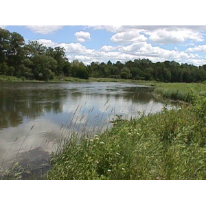
A mostly forested area nestled by the Grand River on the east side of Kitchener. There is a large grassy field, firepit, kybo, and picnic shelter with tables. The Walter Bean Grand River Trail goes right around the edge of the camp. The Grand Valley Trail is nearby. Access to the Grand River provides the opportunity for canoeing.
For More Information
| Information | Web Site |
|---|---|
| Bookings | Phone: +1 519 742 8325 |
Driving Directions
Nearest Other Camps
- NCamp Heidelberg (12 km)
- CDover Street Scout Hall (13 km)
- NHespeler Scout House (15 km)
- CPreston Scout House (15 km)
- OBarber Memorial Scout Camp (23 km)
- OCamp Impeesa (25 km)
- CPeacehaven Scout Camp (27 km)
- OEverton Scout Camp (32 km)
- OBlue Springs Scout Reserve (34 km)
- CShegardaynou Scout Camp (35 km)
This information was gathered from reader contributions: use at your own risk.