
Wildfang Scout Park
Updated: 2008-09-07. Something not right? Please update the information.
| Size | 2.4 ha (6 acres) |
|---|---|
| Coordinates | 44.172597,-81.638889 |
| Street Address | Wildfang Ln, Kincardine, ON (Map may be inaccurate) |
| Nearest town | Kincardine, Ontario |
| NTS Map | 41A/4: Kincardine |
| Operated by | Scouts Canada, Shining Waters Council, Sunset Area, 1st Kincardine Scout Group |
| Information | empty |
| Bookings | Same as above |
| Accommodation | Facilities | Program |
|---|---|---|
| Tenting sites: Yes Adirondack shelters: No Villages: No Cabins: No |
Drinking water: No Emergency phone: No Mobile phone coverage: Unknown Electric vehicle charging: No Picnic tables: No Cooking shelters: No Appliances in cabins: No On-site store: No Shopping nearby: Yes Showers: No Indoor washrooms: No Wheelchair washroom: No |
|
Description
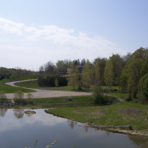
Wildfang is a very small Scout park located near downtown Kincardine. The site is bounded by the Penetangore River to the north, Queen Street to the east, Huron Terrace to the west, and some woods on a steep slope to the south. It has easy access to the Kincardine municipal trail system just across Queen Street. The central business district and harbour are both a short walk from the park. The property was donated by Dr. Wildfang in 1944.
For More Information
| Information | empty |
|---|---|
| Bookings | Same as above |
Driving Directions
Nearest Other Camps
- URobinson Property (0.7 km)
- NCamp Klahanie (53 km)
- CCamp Union Marsh (55 km)
- CWiarton Scout Sailing Centre (77 km)
- OCamp Charl'Bro (88 km)
- OAttawandaron Scout Reserve (107 km)
- NCamp Heidelberg (111 km)
- CCamp Wildwood (114 km)
- OCamp Sylvan (115 km)
- OCamp Mohawk (121 km)
This information was gathered from reader contributions: use at your own risk.