Camp Traill
Status: Appeal successful
Updated: 2017-11-28. Something not right? Please update the information.
| Size | 140 ha (346 acres) |
|---|---|
| Coordinates | 44.554692,-75.975271 |
| Street Address | empty |
| Nearest town | Charleston, Ontario, 30 km west of Brockville |
| NTS Map | 31C/8: Gananoque |
| Operated by | Scouts Canada, Voyageur Council |
| Information | Web Site; Contact: Susan Malanka |
| Bookings | Perry Sine |
| Accommodation | Facilities | Program |
|---|---|---|
| Tenting sites: Yes Adirondack shelters: No Villages: No Cabins: Yes |
Drinking water: No Emergency phone: No Mobile phone coverage: Unknown Electric vehicle charging: Unknown Picnic tables: Yes Cooking shelters: No Appliances in cabins: No On-site store: No Shopping nearby: No Showers: No Indoor washrooms: No Wheelchair washroom: No |
|
Description
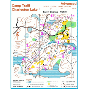
Camp Trail is a wilderness site with an extensive trail network and easy access to Charleston Lake Provincial Park. There are dozens of wooded camp sites, one cabin, and a camporee field. Detailed orienteering maps are available.
For More Information
| Information | Web Site; Contact: Susan Malanka |
|---|---|
| Bookings | Perry Sine |
Driving Directions
Nearest Other Camps
- CRock Dunder Wilderness Camp (18 km)
- OCamp Folly (26 km)
- CCamp Oskenonton (35 km)
- OWhispering Pines (35 km)
- OOtter Lake Scout Camp (46 km)
- OCamp Opemikon (46 km)
- CMcDermott Farm (64 km)
- NCamp No'Chimik (73 km)
- OCamp Sheldrick (77 km)
- CBase Rideau (92 km)
This information was gathered from reader contributions: use at your own risk.
