
Camp Boyle
Updated: 2021-02-22. Something not right? Please update the information.
| Size | 65 ha (161 acres) |
|---|---|
| Coordinates | 49.67286,-119.816748 |
| Street Address | 920 Fish Lake Rd, Summerland, BC (Map may be inaccurate) |
| Nearest town | Summerland, British Columbia |
| NTS Map | 82E/12: Summerland |
| Operated by | Scouts Canada, Cascadia Council |
| Information | Web Site; Contact: South Okanagan Properties |
| Bookings | Same as above |
| Accommodation | Facilities | Program |
|---|---|---|
| Tenting sites: Yes Adirondack shelters: No Villages: No Cabins: Yes |
Drinking water: No Emergency phone: Yes Mobile phone coverage: No Electric vehicle charging: No Picnic tables: Yes Cooking shelters: Yes Appliances in cabins: No On-site store: No Shopping nearby: No Showers: Yes Indoor washrooms: Yes Wheelchair washroom: No |
|
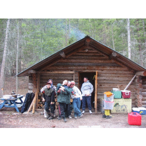
Description
A creek runs through Camp Boyle. There are hiking trails and a beautiful outdoor chapel. The site is great for cross country skiing and bike trips along the local roads. Three kilometres north of the camp is Darke Lake which can be used for canoeing and swimming. There are tenting areas and three cabins of various sizes.
For More Information
| Information | Web Site; Contact: South Okanagan Properties |
|---|---|
| Bookings | Same as above |
Driving Directions
Nearest Other Camps
- OCamp Dunlop (24 km)
- OUpper Apex Mountain Cabin (27 km)
- OLower Apex Mountain Cabin (32 km)
- OHydraulic Lake Wilderness Cabins (47 km)
- OPear Lake Wilderness Cabin (47 km)
- OCamp Secrest (51 km)
- UNicola Lake Camp (78 km)
- CCamp Cove (150 km)
- OMorris Valley Scout Camp (155 km)
- ORuckell Point Scout Camp (St. Ives) (158 km)
This information was gathered from reader contributions: use at your own risk.